Have you ever wondered where the Colorado River actually begins and where it finally ends? You might be surprised to learn that there isn’t just one Colorado River in the United States—there are two, and they each have their own unique paths and stories.
Whether you picture the stunning Grand Canyon carved by the western Colorado River or the vibrant city of Austin nestled along Texas’s Colorado River, understanding where these rivers start and finish can change the way you see the landscapes they shape.
You’ll discover the origins, journeys, and destinations of both Colorado Rivers, helping you make sense of their names, routes, and why they matter to you. Keep reading to uncover the fascinating tale behind these two rivers and why knowing their paths is more interesting than you might think.

Credit: kdvr.com
Two Colorado Rivers
Many people do not realize there are two different Colorado Rivers in the United States. Both share the same name but have distinct paths and features. Knowing about these two rivers helps clear up common confusion.
One Colorado River starts high in the Rocky Mountains and flows southwest. The other stays entirely within Texas and moves southeast. Each river has its own story and importance.
Colorado River Of The Western U.s.
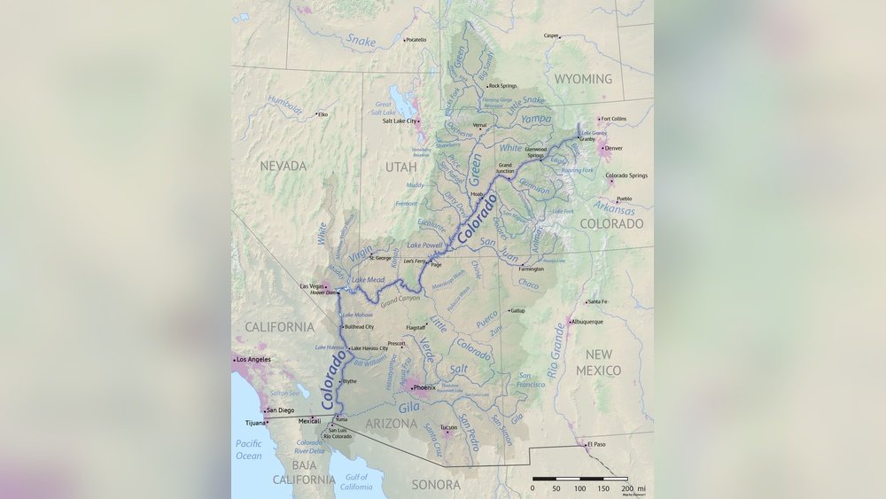
This Colorado River begins in the Rocky Mountains of Colorado. It flows through several states including Utah and Arizona. Along the way, it carves the famous Grand Canyon. The river ends in the Gulf of California, Mexico. It serves as a vital water source for many western states.
Texas Colorado River
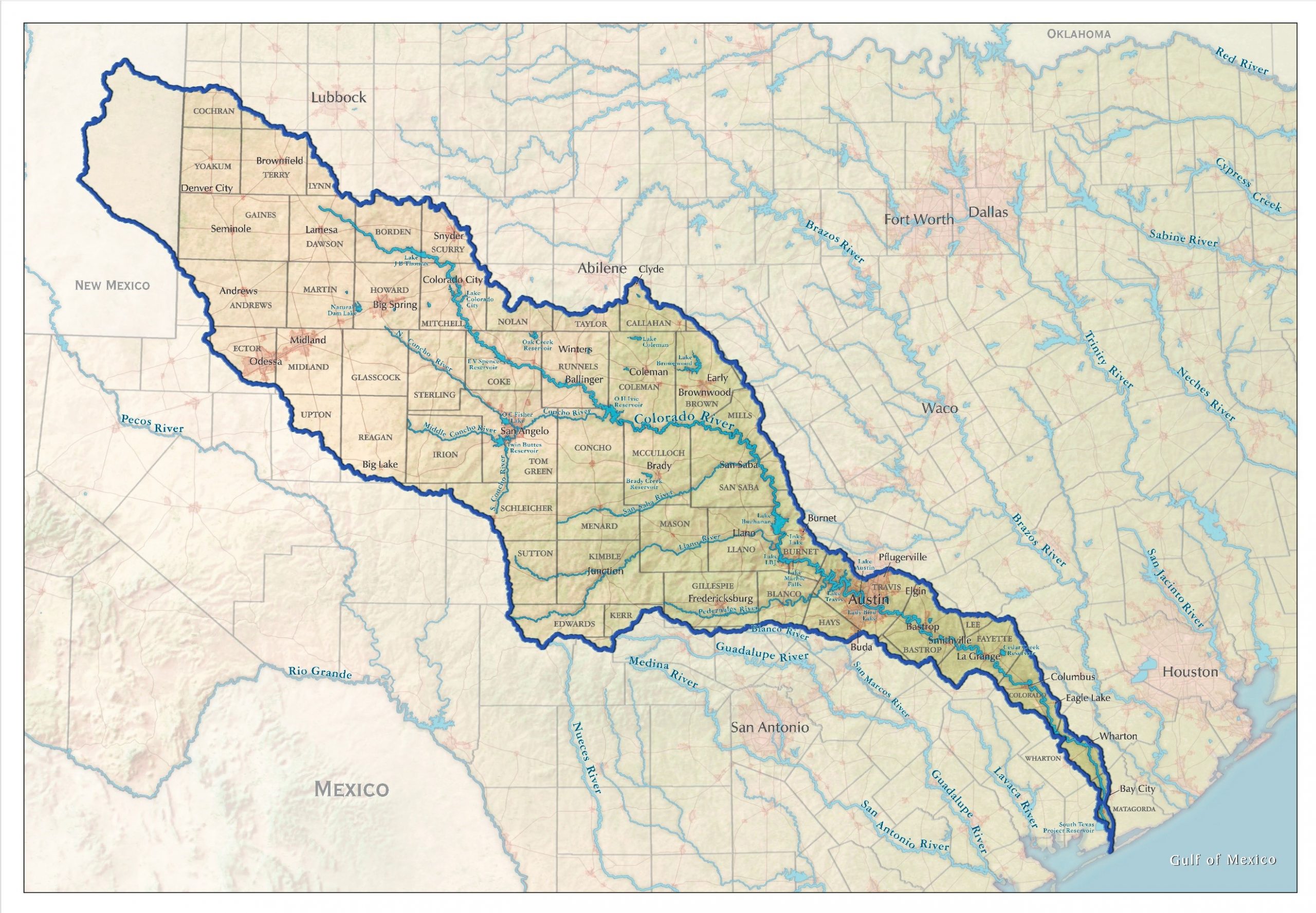
The Texas Colorado River is different. It starts in the northwest part of Texas. It flows southeast through cities like Austin. This river empties into Matagorda Bay on the Gulf of Mexico. The Texas river is important for local water supply and recreation.
Source Of Western Colorado River
The Western Colorado River begins high in the Rocky Mountains. It starts near the Continental Divide in the state of Colorado. This area is known for its rugged peaks and snowy winters.
Snowmelt and mountain springs feed the river’s headwaters. The cold, clear water flows down steep valleys and through alpine forests. This early section of the river is vital for the ecosystems and communities downstream.
The Rocky Mountains: Birthplace Of The River
The Rocky Mountains are the main source of the Western Colorado River. Snow accumulates here during winter. When it melts in spring, the water collects into streams. These small streams join to form the river’s beginning.
The high elevation keeps the river cold and pure. The terrain is steep, which makes the river fast-flowing at its source. This strong start shapes the river’s journey across the West.
Continental Divide: The Key Water Divide
The Continental Divide runs through the Rocky Mountains. It separates rivers flowing to the Pacific Ocean from those flowing east. The Colorado River starts just west of this divide.
This location means the river’s waters flow southwest. It travels far, crossing several states before reaching the ocean. The divide plays an important role in directing the river’s path.
Headwaters In Rocky Mountain National Park
Rocky Mountain National Park holds many sources of the Colorado River. Several creeks merge here to create the river’s main channel. This protected area helps preserve the river’s clean water.
The park’s natural beauty draws visitors and supports wildlife. The river’s headwaters in this park are crucial for water supply downstream. Many cities and farms rely on this water.
Path Through States
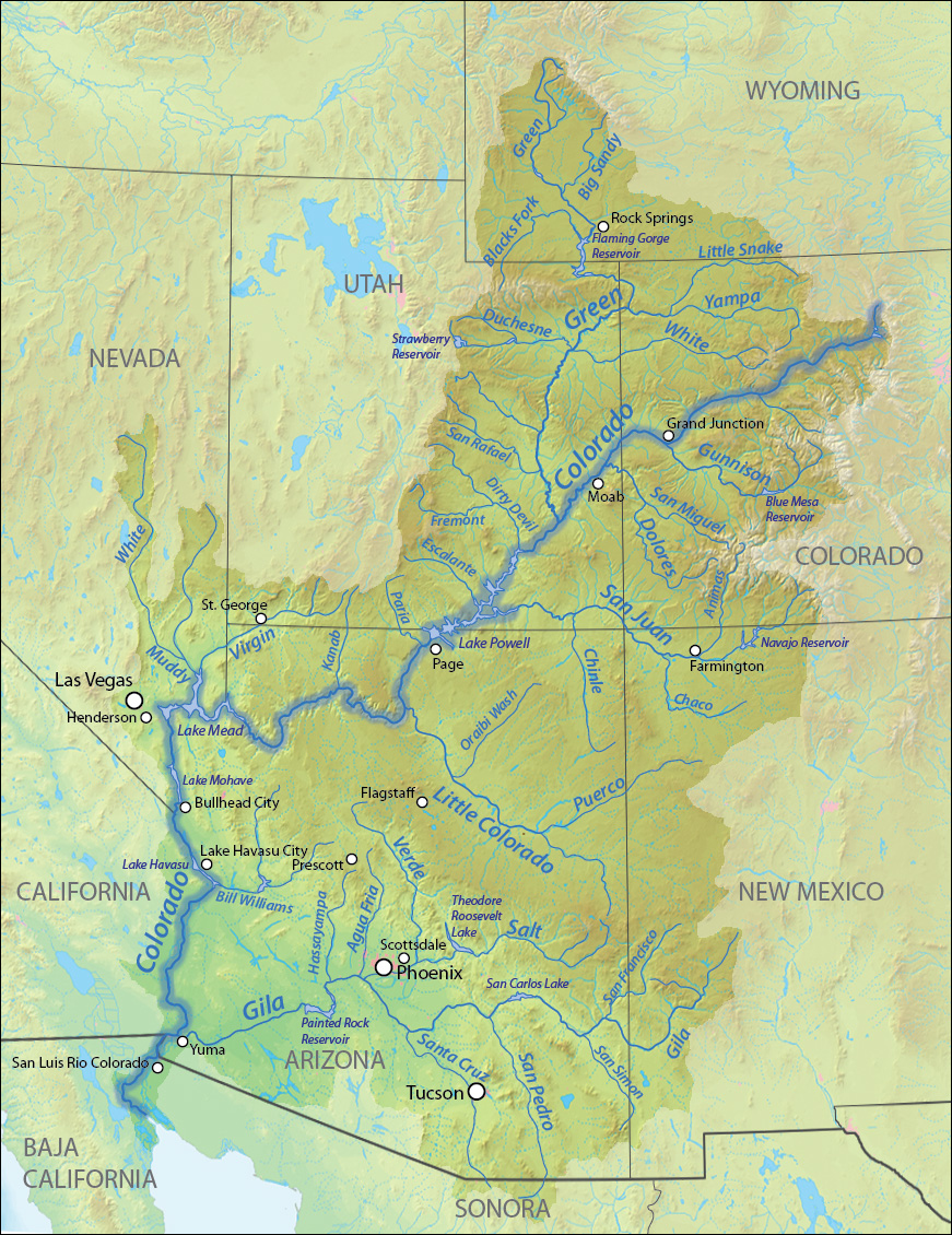
The Colorado River begins in Colorado’s Rocky Mountains and ends at the Gulf of California in Mexico. It flows through several states, shaping famous landmarks like the Grand Canyon along its path. This river plays a vital role in water supply across the western United States.
The Colorado River travels through several states on its long journey. It starts high in the Rocky Mountains. From there, it moves through diverse landscapes and climates. The river shapes the land and supports many communities along the way.
Understanding the river’s path helps explain its importance. It crosses state borders and provides water for millions. Each state along the river has a unique relationship with it.
Colorado: The Rocky Mountain Beginning
The Colorado River begins in the Rocky Mountains of Colorado. Snowmelt feeds the river, making it full and strong. It flows through deep canyons and wide valleys. This start is crucial for the river’s flow downstream.
Utah: Canyons And Desert Landscapes
Next, the river enters Utah, where it carves famous canyons. The red rock formations here are world-renowned. The river supports desert plants and animals. It also feeds reservoirs and provides water to nearby towns.
Arizona: The Grand Canyon’s Sculptor
In Arizona, the Colorado River creates the Grand Canyon. This natural wonder draws visitors worldwide. The river’s power shaped the canyon over millions of years. It remains a vital water source for the region.
California And Nevada: The Lower Basin
The river then flows along the borders of California and Nevada. It supports farms, cities, and deserts. Water from the river helps grow crops in dry areas. Reservoirs like Lake Mead store water for millions of people.
Mexico: The River’s End
The Colorado River ends in Mexico. It flows into the Gulf of California. Here, the river meets the sea, creating rich wetlands. These wetlands support fish, birds, and other wildlife. The river’s journey ends but its impact continues.
Western River’s End Point
The Colorado River in the West begins in the Rocky Mountains and ends at the Gulf of California. Its journey shapes the Grand Canyon and supplies water to several states. The river’s end marks the border between the U. S.
and Mexico.
The Colorado River in the western United States ends its journey at the Gulf of California. This gulf lies between the Baja California Peninsula and mainland Mexico. The river flows southwest from the Rocky Mountains through several states before reaching this point.
At its end, the Colorado River creates a delta, a rich area of wetlands and wildlife habitats. This delta is vital for many species of birds and fish. Over time, water use and dams have reduced the river’s flow, shrinking the delta significantly.
The river’s end marks the boundary between the United States and Mexico in some places. This area has cultural, ecological, and economic importance. The Colorado River’s path from mountain to sea shows how water shapes landscapes and supports life.
Source Of Texas Colorado River
The Texas Colorado River begins in northwest Texas and flows southeast to Matagorda Bay. It passes through Austin and forms several reservoirs along its path. This river is separate from the Western Colorado River, which starts in the Rocky Mountains.
The Texas Colorado River begins in the northwest part of Texas. Its source lies near Lubbock, close to the Llano Estacado region. This area is a large plateau that stretches across parts of Texas and New Mexico.
Rainfall and underground springs feed the river at its start. The river gathers water from small streams and creeks in this dry region. These sources create the river’s headwaters, where it first appears as a small stream.
Geography Of The River’s Origin
The river flows southeast from the Llano Estacado. It crosses diverse landscapes like plains, valleys, and hills. This path shapes the river’s course through central Texas.
Near its start, the river runs through rural lands and small towns. It then moves toward larger cities, including Austin, the state capital. The river’s early journey influences local ecosystems and communities.
Importance Of The Source Area
The source region is vital for water supply in Texas. It provides water for agriculture, wildlife, and people. Protecting this area helps maintain the river’s flow and health.
Without a steady source, the river would dry up downstream. This would affect farms, cities, and natural habitats. The river’s start is the foundation of its entire system.
Credit: coloradoriver.org
Texas River Route
The Texas Colorado River begins in northwest Texas and flows southeast to Matagorda Bay. It passes through cities like Austin and forms the Highland Lakes. This river is different from the Colorado River that starts in the Rocky Mountains and ends in the Gulf of California.
Texas River Route Overview
The Texas Colorado River flows entirely within Texas state boundaries. It starts in the northwest part of Texas and moves southeast. The river ends at Matagorda Bay, which connects to the Gulf of Mexico. This river is much smaller than the western Colorado River. It plays a key role in Texas water supply and recreation.
Starting Point Of The Texas Colorado River
The river begins near Lubbock, Texas, in the Llano Estacado region. From here, it gathers water from small streams and rainfall. The river’s source is not a single spring but a collection of runoff areas. This helps feed the river as it travels southeast.
Major Cities Along The Texas Colorado River
Austin, the capital city of Texas, sits on this river. The river provides water and natural beauty for Austin. Other cities along the route include Lampasas and Bastrop. These communities rely on the river for drinking water and outdoor activities.
Highland Lakes Reservoir System
The Texas Colorado River forms a chain of reservoirs called the Highland Lakes. These lakes help control flooding and store water. They also offer spots for fishing, boating, and camping. The lakes are popular with both locals and visitors.
Ending Point At Matagorda Bay
After flowing southeast, the river empties into Matagorda Bay. This bay is part of the Gulf of Mexico. The river’s fresh water mixes with the saltwater of the gulf here. This area supports diverse wildlife and important fishing industries.
Texas River’s End Point
The Texas Colorado River begins in the northwest part of the state and ends at Matagorda Bay on the Gulf of Mexico. It flows southeast, passing through cities like Austin and forming several reservoirs along the way. This river is separate from the Western Colorado River.
The Texas Colorado River ends in a unique place. It flows southeast across Texas and reaches the Gulf of Mexico. Specifically, it empties into Matagorda Bay, a large estuary on the Texas coast. This bay connects the river’s freshwater to the salty waters of the Gulf.
Matagorda Bay serves as a rich habitat for fish and birds. It supports both wildlife and local industries like fishing. The river’s journey to this bay shapes the landscape and ecology of the coastal region.
Matagorda Bay’s Role
Matagorda Bay acts as a natural filter for the river water. It balances salt and fresh water, creating a healthy environment. This mix supports oyster beds and seagrass, vital for marine life.
The bay also protects the inland areas from storms. It absorbs floodwaters and reduces erosion along the coast. This makes it an important natural barrier for Texas communities.
Impact On Local Communities
Several towns and cities near the river’s end rely on its waters. Fishing, tourism, and boating are common activities. The river helps support jobs and local economies in these areas.
Water from the Colorado River also irrigates farms near the coast. It provides fresh water for crops and livestock. This makes the river a key resource for both nature and people at its end point.
Grand Canyon’s Formation
The Colorado River begins in the Rocky Mountains of Colorado and ends in the Gulf of California, Mexico. It carved the Grand Canyon over millions of years, shaping one of the world’s most famous natural wonders. The river flows through several states on its long journey southwest.
The Grand Canyon is one of the world’s most famous natural wonders.
It formed over millions of years through natural processes.
The Colorado River played a key role in shaping the canyon.
Role Of The Colorado River
The Colorado River started cutting through rock layers about six million years ago.
Its flowing water slowly wore away the rock, deepening the canyon.
Floods and seasonal flows helped widen the canyon over time.
Geological Layers Exposed
The canyon reveals many rock layers, each telling a story of Earth’s past.
These layers include limestone, sandstone, and shale.
The river’s erosion exposed fossils and ancient sediments.
Impact Of Climate And Erosion
Rain, wind, and temperature changes also shaped the canyon’s cliffs and valleys.
These forces worked with the river to create the canyon’s unique shapes.
Freeze-thaw cycles caused rock to crack and fall into the river.
Water Use And Dams
The Colorado River is a vital water source in the western United States. It supports millions of people, farms, and wildlife. To manage this precious resource, many dams have been built along its course. These dams help control floods, store water, and generate electricity.
Water use along the Colorado River is carefully regulated. The river supplies water to seven states and Mexico. Each region relies on the river for drinking water, irrigation, and industry. The balance between water use and conservation is a constant challenge.
Major Dams On The Colorado River
Some of the largest dams on the Colorado River include Hoover Dam and Glen Canyon Dam. Hoover Dam creates Lake Mead, the largest reservoir in the U.S. Glen Canyon Dam forms Lake Powell, another huge water storage site. These dams help regulate river flow and provide hydroelectric power.
Impact Of Dams On Water Flow
Dams change the natural flow of the river. They hold back water during wet periods and release it during dry times. This helps prevent floods and droughts downstream. However, it also reduces sediment flow, affecting river habitats and the Grand Canyon’s ecosystem.
Water Use And Allocation
The Colorado River Compact divides water rights between states. This agreement sets limits on how much water each state can use. Cities like Las Vegas, Phoenix, and Los Angeles depend on these water shares. Agriculture uses the largest portion, especially in California and Arizona.
Environmental Impact
The Colorado River’s journey from the Rocky Mountains to the Gulf of California shapes many ecosystems. Its environmental impact is significant and complex. The river supports wildlife, plants, and human communities along its path. Water use, pollution, and climate change affect its health and flow. Understanding these effects helps protect this vital water source.
Water Diversion And Habitat Loss
Dams and water diversion projects reduce the river’s natural flow. This change harms fish and other aquatic life. Wetlands and riparian areas shrink, losing their habitats. Many species depend on these areas for food and shelter. Reduced water flow also affects the river’s ability to cleanse itself.
Pollution And Water Quality
Urban and agricultural runoff pollutes the river. Chemicals, fertilizers, and waste enter the water. These pollutants harm fish and plants. Poor water quality also affects people who rely on the river. Efforts to reduce pollution are important for the river’s health.
Impact Of Climate Change
Rising temperatures and changing rainfall patterns affect the river. Snowpack in the Rocky Mountains is declining, reducing water supply. Droughts become longer and more severe. These changes stress ecosystems and water users. Climate change creates new challenges for managing the river.
Credit: www.americanrivers.org
Frequently Asked Questions
Is The Colorado River In Texas The Same As The Colorado River In Colorado?
No, the Colorado River in Texas and the one in Colorado are different rivers. Texas’ river flows southeast to the Gulf of Mexico, while Colorado’s flows southwest through the Grand Canyon to the Gulf of California.
Are There Two Colorado Rivers In The Us?
Yes, the US has two Colorado Rivers. One flows from the Rocky Mountains to the Gulf of California. The other runs entirely within Texas, flowing southeast to the Gulf of Mexico. Both are distinct rivers sharing the same name but different courses and regions.
Does The Colorado River Empty Into The Ocean?
The Colorado River in the western U. S. flows southwest and empties into the Gulf of California. The Texas Colorado River flows southeast into Matagorda Bay on the Gulf of Mexico. Neither river directly empties into the open ocean.
How Many States Does The Colorado River Run Through?
The Colorado River flows through seven U. S. states: Colorado, Wyoming, Utah, New Mexico, Arizona, Nevada, and California.
Where Does The Colorado River Begin?
The Colorado River starts in the Rocky Mountains of Colorado.
Where Does The Colorado River End?
It ends at the Gulf of California in Mexico.
Is The Colorado River In Texas The Same River?
No, Texas has a different Colorado River within its state.
How Long Is The Colorado River?
The Colorado River is about 1,450 miles long.
Which States Does The Colorado River Flow Through?
It flows through Colorado, Utah, Arizona, Nevada, California, and New Mexico.
What Major Landmark Does The Colorado River Carve?
The river carved the famous Grand Canyon in Arizona.
Conclusion
The Colorado River starts high in the Rocky Mountains. It flows southwest through several states. Its journey ends in the Gulf of California. This river shapes landscapes like the Grand Canyon. Meanwhile, the Texas Colorado River begins in the Panhandle.
It flows southeast through cities like Austin. It empties into Matagorda Bay at the Gulf of Mexico. Both rivers share a name but are different. Each river plays a vital role for its region. Understanding where they start and end helps appreciate their importance.
The Colorado River’s path tells a story of nature and life.